|
Clark AB Photos
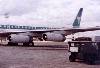 |
Tim Vasquez's photos, Part 2
A collection of my photos from 1980 to 1982, mostly around the
Hill Housing area, and a couple of flightline photos.
|
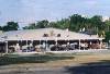 |
Clark 2000: Nowadays
A fascinating tour of significant buildings on the former
Clark Air Base, courtesy of
Mike Ward.
Quick tour of base (various sources)
Bambam Wash near Mactan Housing Area
Hill Housing along Davis Ave
Western Hill Housing
Regional Medical Center
Mactan Housing Area
Unsorted pictures (caution -- some of these may have up to
20 photos and may take a few minutes to load):
1,
2,
3,
4,
5,
6,
7,
8,
9,
10,
11,
12,
13,
14
|
|
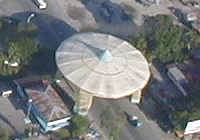 |
Aerial photos
These photographs of Clark were taken in November 2000 by
Mike Ward, who took
an adventurous approach and chartered a Cessna to get a birds' eye view.
In this picture series don't be surprised when I refer to places
as part of "Clark Air Base". Yes, I know it's now the "Clark
Special Economic Zone", but the older placenames are essential
to those of us who lived there decades ago.
Thanks, Mike, for these fantastic photos!
Click on the first photo to start the tour, or click anywhere
in the list to see specific photos.
|
Plaridel II, Angeles City
Carmenville, Angeles City
Main gate area, Angeles City
Dau area, Angeles City
Western area, Clark
Southern airfield, Clark
Airfield, Clark
Abacan River and Friendship 2 gate
Angeles City from west
Western base area, Clark
Entire base (wide view), Clark
Entire base (wide view), Clark
Sacabia River and Mactan
Northern base area (wide view), Clark
Northern base area (zoom), elephant cage, housing
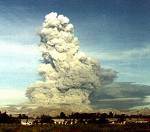
Mount Pinatubo and crater lake
Expo Pilipino (elephant cage)
Airfield (northern side)
Airfield (northern side)
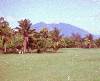
Golf course and Hill Housing
Golf course, FM Washout, and Hill Housing
Hill housing (wide view from west)
Sacabia River (overhead)
Sacabia River (overhead closeup)
Mactan savanna (Mactan and Sacabia River)
Hill Housing area and former Wurtsmith School
Hill Housing area over Clark Ave
Wagner High School
Wagner High School
Dixon Ave Housing
Golf Course and central base area
Central base area
Barn housing area
Lily Hill area
Lily Hill Middle School
Silver Wing area
Motorpool area
Flightline (nice view towards south)
Mabalacat area (mostly northeast part of base)
Mabalacat/Dau from airfield
Clarkview area
Downtown Angeles City
Angeles City / Dau area closeup
Dau area looking east
Pampanga province looking northeast towards Tarlac
Dau area looking west
Dau area and Angeles City
Mabalacat area looking north
Eastern base area with rice fields
|
|